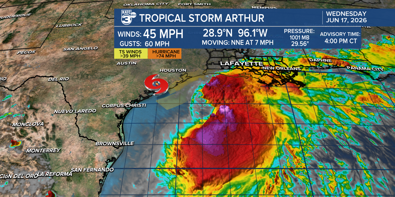
Tropical Storm Arthur has become the first named storm of the 2026 Atlantic hurricane season, already delivering heavy rainfall to the northwestern Gulf Coast region.
The National Hurricane Center placed Arthur approximately 40 miles east-northeast of Port Connor, Texas, as of its latest advisory Wednesday morning.
Arthur’s maximum sustained winds reached 40 mph, just barely clearing the 39 mph threshold required for tropical storm classification.
Forecasters do not expect the storm to strengthen significantly before making landfall, but the flooding risk it carries is considered severe and potentially life-threatening.
The hurricane center warned in its advisory that Arthur is expected to produce rainfall totals of 5 to 10 inches, with isolated higher totals near 20 inches, through early Friday across a wide stretch of the Gulf Coast.
NHC Director Michael Brennan emphasized during an online briefing that rainfall poses the greatest danger, even for communities located hundreds of miles from the coast.
“The main threat from Arthur is going to be a prolonged multi-day heavy rainfall event that could produce dangerous to life-threatening flash flooding,” Brennan said, with a screen behind him showing flood watch advisories stretching from the Texas coast to South Georgia.
Brennan also cautioned that conditions would not immediately improve once the storm center moves inland, saying “that heavy rainfall threat is going to persist even after the center of Arthur moves farther inland and dissipates.”
Arthur is expected to track northeast and push inland over southwestern Louisiana by Wednesday night before dissipating Wednesday night or early Thursday.
A tropical storm warning remains in effect from High Island, Texas, to Morgan City, Louisiana, meaning tropical storm conditions are anticipated within 12 hours of the advisory.
All of Southeast Texas was placed under a flood watch until 7 p.m. Wednesday, with officials in Galveston County urging residents to avoid driving through flooded roadways.
Arthur’s early arrival is notable given that the historical average date for the first named Atlantic storm, calculated from 1991 to 2020, falls on June 20, according to the hurricane center.
The average date for the first Atlantic hurricane across that same period is August 11, meaning the season is off to an earlier-than-typical start.
Climate change continues to amplify hurricane intensity, as warmer sea water evaporates more readily, fueling stronger storms while warmer air retains significantly more moisture, contributing to heavier rainfall events.
The National Hurricane Center’s 2026 seasonal forecast, issued in May, projects fewer storms than average, partly due to the recently declared El Niño, which typically suppresses Atlantic hurricane formation.
However, forecasters caution that warmer ocean temperatures increase the likelihood of at least one large and destructive storm forming, and a single powerful hurricane can bring catastrophic rainfall and storm surges far inland.